
Forest Biomass Disturbance Monitoring Use Case
Monitoring forest disturbances such as logging, windthrow, fires, pests, and diseases is critical for biodiversity conservation, climate mitigation, and sustainable forest management. Satellite imagery offers unprecedented opportunities for observing forests at continental scale, but the technical barriers to working directly with Earth Observation (EO) data remain high.
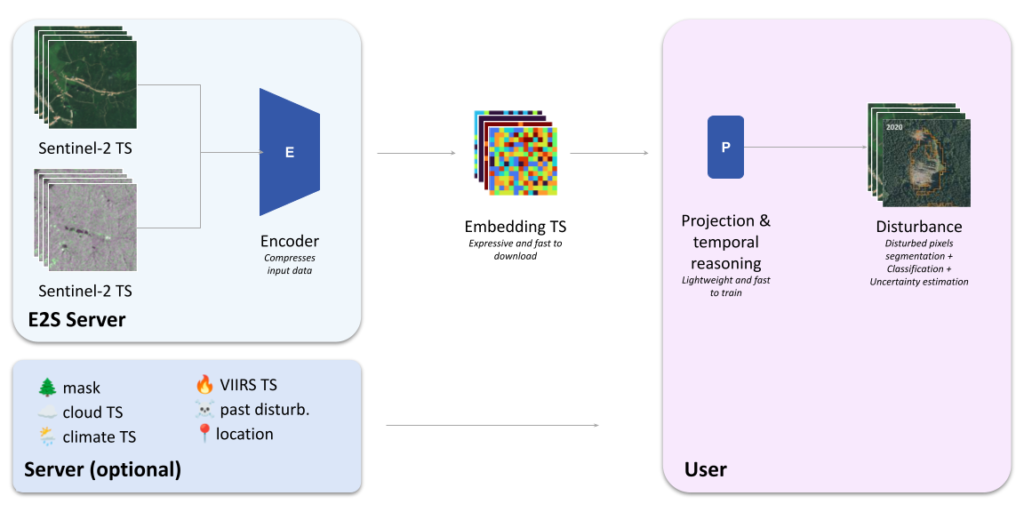
Within the Embed2Scale project, the Forest Disturbance Monitoring use explores a new paradigm for forest monitoring based on geospatial foundation model (GFM) embeddings. Instead of distributing raw satellite imagery, the approach focuses on compact, information-rich representations that allow users to build monitoring systems without handling large EO datasets or training deep learning models from scratch.
Data sources used
The use case relies on data are from the European Copernicus Sentinel missions, which provide continuous, high-resolution observations of the Earth’s surface.
The primary data sources are:
- Sentinel-2 optical imagery
- Sentinel-1 synthetic aperture radar (SAR) imagery
These sensors provide complementary information:
- Sentinel-2 captures optical reflectance across multiple spectral bands, enabling the analysis of vegetation health and canopy structure.
- Sentinel-1 is a radar sensor capable of acquiring data regardless of cloud cover or daylight conditions, making it particularly valuable for consistent monitoring.
Key characteristics of the data used in this project include:
- Spatial resolution: 10 meters
- Temporal coverage: the full history of the Sentinel missions
- Geographic coverage: initially Europe, with potential extension to global scale
The system is designed to ingest asynchronous streams of Sentinel-1 and Sentinel-2 observations, enabling continuous monitoring as new satellite acquisitions become available.
Methodology
Traditional EO workflows require downloading large volumes of imagery and building specialised processing pipelines. This use case instead leverages geospatial foundation models, which learn general-purpose representations from large volumes of satellite data.
The proposed pipeline works as follows:
- Raw EO time series from Sentinel-1 and Sentinel-2 are collected.
- These time series are processed by a geospatial foundation model capable of handling multi-modal inputs.
- The model produces a time series of embeddings — compact numerical representations that capture the spatial and spectral characteristics of the observations.
- These embeddings are distributed through a centralised server, where users can query and download representations for specific locations and time periods.
- Downstream models operate directly on the embeddings to perform tasks such as early disturbance detection and disturbance agent attribution.
A key requirement for the foundation models considered in this project is their ability to:
- handle multi-modal inputs (Sentinel-1 and Sentinel-2),
- remain robust when one modality is missing, and
- produce spatially dense feature maps, which are essential for precise disturbance localisation.
Research is ongoing to benchmark different GFMs that satisfy these requirements.
Embeddings
Embeddings are compact vector representations produced by a geospatial foundation model. Instead of storing raw imagery, the model encodes the relevant information into a lower-dimensional representation that can be used for downstream analysis.
In this project, embeddings are generated as a time series of spatial feature maps, where each embedding summarises the information contained in the corresponding satellite observations.
These embeddings act as a bridge between large EO datasets and lightweight machine learning workflows. Users can train simple models on top of them without needing to access or process the underlying satellite imagery.
The exact characteristics of the embeddings — such as their dimensionality, spatial resolution, and compression strategy — will depend on the selected foundation model and are being investigated as part of the project.
Expected Impact
Using embeddings instead of raw EO imagery offers several advantages for operational forest monitoring.
Lower technical barriers
Working with satellite data typically requires specialised expertise in remote sensing, large data storage, and high-performance computing. Embeddings significantly reduce these requirements by providing compact, ready-to-use representations.
Reduced data transfer and storage
Satellite imagery datasets can be extremely large. Embeddings are much smaller and therefore easier to distribute, store, and analyse.
Faster model development
Users can build monitoring models directly on top of embeddings using relatively simple machine learning techniques, without training large deep learning architectures.
Improved analytical capabilities
Geospatial foundation models learn rich spatial, spectral, temporal, and multi-modal representations from massive EO archives. Leveraging these representations may enable more powerful learning-based approaches for forest disturbance monitoring than traditional feature engineering pipelines.
Regional customisation
Embedding-based workflows make it easier to adapt monitoring systems to new regions or forest types using limited local annotations.
Future work
Several research directions are explored for this use case and may continue beyond the project timeframe.
New benchmarking datasets
A computer vision benchmark for near real-time forest disturbance detection and agent attribution will be assembled to support systematic evaluation.
Benchmarking geospatial foundation models
Existing GFMs pretrained on Sentinel-1 and Sentinel-2 data are evaluated to determine which provide the most informative embeddings for disturbance monitoring.
Temporal reasoning for disturbance detection
A major research focus will be the development of temporal models that analyse embedding time series in order to detect disturbances as early as possible and attribute their likely causes.
Continental-scale disturbance mapping
In collaboration with experts in forest monitoring, this research direction would pave the way to producing high-resolution disturbance maps at European scale covering the full Sentinel mission history.

References
- Van der Woude, S., Reiche, J., Balling, J., et al. (2026) European forest disturbance alerting using Sentinel-1. Remote Sensing of Environment
- Pickens, A. H., Hansen, M. C., Song, Z., et al. (2025) Rapid monitoring of global land change, Nature Communications
- Schwartz, M., Fogel, F., Besic, N., et al. (2025) FORMSpoT: A Decade of Tree-Level, Country-Scale Forest Monitoring, Remote Sensing of Environment
- Mermoz, S., Doblas Prieto, J., Planells, M., et al. (2024) Submonthly Assessment of Temperate Forest Clear-Cuts in Mainland France, IEEE Journal of Selected Topics in Applied Earth Observations and Remote Sensing
- Viana-Soto, A., Senf, C. (2024) The European Forest Disturbance Atlas: a forest disturbance monitoring system using the Landsat archive, Earth System Science Data
- Turubanova, S., Potapov, P., Hansen, M. C., et al. (2023) Tree canopy extent and height change in Europe (2001–2021) using the Landsat archive, Remote Sensing of Environment
- Karaman, K., Sainte Fare Garnot, V., Wegner, J. D. (2023) Deforestation detection in the Amazon with Sentinel-1 SAR image time series, ISPRS Annals of the Photogrammetry, Remote Sensing and Spatial Information Sciences
- Reiche, J., Mullissa, A., Slagter, B., et al. (2021) Forest disturbance alerts for the Congo Basin using Sentinel-1, Environmental Research Letters